Wgs84
Advertisement

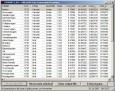
Geo Data International Streets
For many countries street coordinates are present with coverage degrees of 100 percent. The geo data offered here are in high-precision quality and are present in several coordinate and reference systems (Geographic, UTM / WGS84, ETRS89). Street
Advertisement
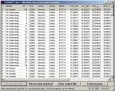
Geo Data International Houses
For many countries house coordinates are present with coverage degrees of 100 percent. The geo data offered here are in high-precision quality and are present in several coordinate and reference systems (Geographic, UTM / WGS84, ETRS89). House Coordinates

GPSTools v.1.9.0.0
Use GPS tools to display your location. Both "Degree Minute Second" (DMS) as "Decimal Degree" (DD) is supported. Data to various UTM datums. (WGS84, NAD83, etc) Storage capability for your Points of Interest, user input supports both DMS and DD

GeoGPS v.1.3.0.0
Turn your Windows Phone to a full-featured hand held GPS device with this App. Designed for navigation, finding directions and planning outdoor activities or at sea. Suitable for work with paper charts and plans even beyond WGS84. • Set waypoints
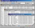
Geodata International v.10.05
Geodata International - World-wide database of countries with georeferenced towns, municipalities, postal codes and administrative units with WGS84 and UTM coordinates and elevations for geocoding, proximity search, navigation, distance calculation.
Geodaten International v.6.01
Geodata International - World-wide database of countries with georeferenced towns, municipalities, postal codes and administrative units with WGS84 and UTM coordinates and elevations for geocoding, proximity search, navigation, distance calculation.
AllTrans
AllTrans can be used for world wide professional coordinate transformations between international and national coordinate systems with or without geodetic datum change. Transformations between State-Plane-Coordinates (NAD83, NAD27, Transverse Mercator,
TOPOWIN v.16.00
TOPOWIN is a state-wide register of the German topographic cartographies and of localities with geo references in different coordinate systems. It also is a topographic information system.
ORTWIN v.13.02
ORTWIN is a program for the inquiry of localities in Germany. It finds postal zip codes, telephone pre selections, coordinates. It performs perimeter searches and distance calculations. It finds landscapes, natural units, snow- and wind load zones.
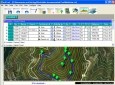
EdiTrail v.1.0
Create/Edit/Display/Management/Import/Export Trails/Routes in a simple and flexible environment divided in a data table for the management of trails and a map resulting from numerous providers, (Bing, Arcgis, Ovi, Yahoo, etc).
GPSMaster v.2.13.5.879
GPSMaster is a program that runs under Windows on a PC and is able to communicate with a Garmin GPS. You can download all the desired data from your GPS, edit it, save it, view it, print it, upload it.